Habitant dans une région quelque peu sismique j’ai décidé de me lancer dans la création d’un script pouvant récupérer les données fournies par le site du RéNaSS (Réseau National de Surveillance Sismique)
En cherchant un peu sur leur site j'ai fini par tomber sur deux APIs :
- Une en JSON
- Une en QuakeML (XML dédié aux données sismiques et sismologiques)
En m'inspirant ( Énormément
 ) du script de localisation de l'iss de papoo, j'ai réussi, non sans mal, à créer une ébauche que voici :
Code : Tout sélectionner
---------------------------------------------------------------------------
-- script_time_renass.lua -------------------------------------------------
-- DumpDos ----------------------------------------------------------------
---------------------------------------------------------------------------
-- Ce script est dédié à la récupération des données fournies par l'api ---
-- du RéNaSS --------------------------------------------------------------
---------------------------------------------------------------------------


-------------------------------------------------------------------------------------------------------------
-------------------------------------------- Informations ---------------------------------------------------
-------------------------------------------------------------------------------------------------------------

-- Site 				: http://renass.unistra.fr
-- API XML  			: http://renass.unistra.fr/fdsnws/event/1/query?latitude=46.6&longitude=1.9&maxradius=9&minmagnitude=1&orderby=time&starttime=2016-11-28&endtime=2016-11-29&format=qml
-- API JSON 			: http://renass.unistra.fr/fdsnws/event/1/query?latitude=46.6&longitude=1.9&maxradius=9&minmagnitude=1&orderby=time&starttime=2016-11-28&endtime=2016-11-29&format=json
-- Post forum			: https://easydomoticz.com/forum/viewtopic.php?f=17&t=2884
-- Script inspiré de 	: https://easydomoticz.com/forum/viewtopic.php?f=17&t=2310

-------------------------------------------------------------------------------------------------------------
----------------------------------------- Variables à Editer ------------------------------------------------
-------------------------------------------------------------------------------------------------------------

local Lat				= "45.0000"		-- Latitude de votre logement
local Lon				= "5.0000"		-- Longitude de votre logement
local Ville				= "ville"	-- Lieu de résidence
local Magnitude 		= "0.1"			-- Magnitude minimale de détection des séismes
local Rayon				= "2"			-- Rayon de détection des séismes
local Plage_horaire		= "2"			-- Plage horaire de détection
local Seisme_disp		= "391"			-- Idx du capteur texte
local Magnitude_disp	= "610"			-- Idx du capteur graphique magnitude (false = Désactivé)
local Distance_disp		= false			-- Idx du capteur graphique distance (false = Désactivé)
local Magnitude_noti	= 4				-- Magnitude minimale de notification (false = Désactivé)
local Print_logs		= true			-- Affichage des données dans les logs

-------------------------------------------------------------------------------------------------------------
---------------------------------------- Variables de Travail -----------------------------------------------
-------------------------------------------------------------------------------------------------------------
noti 		= tonumber(Magnitude_noti)
year		= tonumber(os.date("%Y"));
month		= tonumber(os.date("%m"));
day			= tonumber(os.date("%d"));
heure		= tonumber(os.date("%H")) - tonumber (Plage_horaire);
rayon_terre	= 6378

--------------------------------------------------------------------------------------------------------------
---------------------------------------------- Fonctions -----------------------------------------------------
--------------------------------------------------------------------------------------------------------------

-- Fonction conversion radian --
function radian(valeur)
return ((math.pi * valeur)/180)
end

-- Fonction arrondi --
function arrondi(nombre, decimales)
  local conversion = 10^(decimales or 0)
  return math.floor(nombre * conversion + 0.5) / conversion
end

-- Fonction debugging --
function logs (x, Print_logs)
	 if (Print_logs) then
     print (x)
	 end
end

-- Fonction mise à jour des capteurs virtuels --
function update(idx, valeur1)
    local commande = string.format("%d|0|%.2f", idx, valeur1 )
    table.insert (commandArray, { ['UpdateDevice'] = commande } )
end

--------------------------------------------------------------------------------------------------------------
------------------------------------------------ Fin ---------------------------------------------------------
--------------------------------------------------------------------------------------------------------------

commandArray = {}

now = os.date("*t")

-- Execution du script toutes les 30 minutes --
if now.min % 30 == 0 then

	-- Vérification des conditions --
	if Lat ~= nil and Lon ~= nil and  Ville ~= nil and Seisme_disp ~= nil then

	  -- Affichage d'éxécution --
	  print('script_time_renass_json.lua')

	-- Emplacement du fichier JSON.lua --
	json = (loadfile "/home/pi/domoticz/scripts/lua/JSON.lua")()
	--json = (loadfile "D:\\Domoticz\\scripts\\lua\\json.lua")()  -- Windows
	--json = (loadfile "/volume1/@appstore/domoticz/var/scripts/lua/JSON.lua")() -- Synology

	  -- Decodage des données
      local config=assert(io.popen('curl --connect-timeout 10 "https://renass.unistra.fr/fdsnws/event/1/query?latitude='.. Lat ..'&longitude='.. Lon ..'&maxradius='.. Rayon ..'&minmagnitude='.. Magnitude ..'&starttime='.. year ..'-'.. month ..'-'.. day ..'T'..heure..':00:00&orderby=time-asc&format=json"'))
      local data     = config:read('*all')
      local jsondata = json:decode(data)
      config:close()

      -- Récupération des données --
      if jsondata ~= nil then
            for i, resultat in pairs(jsondata.features) do
		seisme			= resultat.properties
		localisation 	= resultat.geometry

			 -- Récupération des propriétés --
			local releve_brut			= localisation ["coordinates"]	-- Localisation ( Chaîne )
			local releve_description	= seisme ["description"]		-- Description
			local releve_mode			= seisme ["evaluationMode"]		-- Mode de récupération et validation du séisme par le RéNaSS ( Automatique ou Manuel )
			local releve_magnitude		= seisme ["mag"]		    	-- Magnitude
			local releve_unitmag		= seisme ["magType"]			-- Unité Magnitude
			local releve_lieu			= seisme ["place"]				-- Pays d'origine
			local releve_date			= seisme ["time"]				-- Date et Heure (UTC) du séisme ( Chaîne )
			local releve_type			= seisme ["type"]				-- Relevé Type :  séisme / tir de carrière
			local releve_url			= seisme ["url"]				-- URL page originale de l'événement


			 -- Récupération de la localisation --
			local releve_decode1	= table.concat(releve_brut, ",")
			local lon, lat, pro		= string.match (releve_decode1, "(%d+%p%d+),(%d+%p%d+),(.%d+)" )

			 -- Récupération de l'heure --
			local releve_decode2	= tostring (releve_date)
			local h, m, s			= string.match (releve_decode2, "(%d+):(%d+):(%d%d)")
			local releve_heure		= (tonumber (h) + 1)
			local releve_minute		= m

			-- Récupération type de séisme --
			if releve_type == nil then
				 seisme_type = "Séisme"

			elseif releve_type == "earthquake" then
				 seisme_type = "Séisme"

			elseif releve_type == "quarry blast" then
				 seisme_type = "Tir de carrière"

			end

			 -- Affichage des données dans logs --
			logs ("Description = "..releve_description, Print_logs)
			logs ("Type = "..seisme_type, Print_logs)
			logs ("Magnitude = "..releve_magnitude, Print_logs)
			logs ("Latitude = "..lat, Print_logs)
			logs ("Longitude = "..lon, Print_logs)
			logs ("Profondeur = "..pro.." km ", Print_logs)
			logs ("Heure Locale = "..releve_heure..":"..releve_minute, Print_logs)
			logs ("Pays = "..releve_lieu, Print_logs)

			 -- Initialisation des variables --
			local lat_a	= tonumber(radian(Lat))
			local lon_a	= tonumber(radian(Lon))
			local lat_b	= tonumber(radian(lat))
			local lon_b	= tonumber(radian(lon))

			 -- Calcul de la distance --
			local distance_brut = rayon_terre * (math.pi/2 - math.asin( math.sin(lat_b) * math.sin(lat_a) + math.cos(lon_b - lon_a) * math.cos(lat_b) * math.cos(lat_a)))

			 -- Calcul angle --
			local dy	= lat_b - lat_a
			local dx	= math.cos(math.pi/180*lat_a)*(lon_b - lon_a)
			local angle	= math.atan(dy/dx)

			 -- Calcul Azimuth --
			 -- Quart Nord-Est --
			if (lat_b >= lat_a) and (lon_b >= lon_a) then

				 -- Calcul --
				 angle_degres = ((math.pi/2)- angle)/(( math.pi / 2 ) / 90 )

				 -- Définition point de compas --
				if angle_degres > 0 and angle_degres < 11.5 then
					 direction = "N"
				end
				if angle_degres >= 11.5 and angle_degres < 34 then
					 direction = "NNE"
				end
				if angle_degres >= 34 and angle_degres < 56.5 then
					 direction = "NE"
				end
				if angle_degres >= 56.5 and angle_degres < 79 then
					 direction = "ENE"
				end
				if angle_degres >= 79 and angle_degres < 90 then
					 direction = "E"
				end
			end

			 -- Quart Sud-Est --
			if (lat_b <= lat_a) and (lon_b >= lon_a) then

				 -- Calcul --
				 angle_degres =  90 + (((angle) - (angle*2)) / (( math.pi / 2 ) / 90 ))

				 -- Définition point de compas --
				if angle_degres >= 90 and angle_degres < 101.5 then
					 direction = "E"
				end
				if angle_degres >= 101.5 and angle_degres < 124 then
					 direction = "ESE"
				end
				if angle_degres >= 124 and angle_degres < 146.5 then
					 direction = "SE"
				end
				if angle_degres >= 146.5 and angle_degres < 169 then
					 direction = "SSE"
				end
				if angle_degres >= 169 and angle_degres < 180 then
					 direction = "S"
				end
			end

			 -- Quart Sud-Ouest --
			if (lat_b <= lat_a) and (lon_b <= lon_a) then

				 -- Calcul --
				 angle_degres = 180 + (((math.pi/2)- angle) / (( math.pi / 2 ) / 90 ))

				 -- Définition point de compas --
				if angle_degres >= 180 and angle_degres < 191.5 then
					 direction = "S"
				end
				if angle_degres >= 191.5 and angle_degres < 214 then
					 direction = "SSO"
				end
				if angle_degres >= 214 and angle_degres < 236.5 then
					 direction = "SO"
				end
				if angle_degres >= 236.5 and angle_degres < 259 then
					 direction = "OSO"
				end
				if angle_degres >= 259 and angle_degres < 270 then
					 direction = "O"
				end
			end

			 --Quart Nord-Ouest --
			if (lat_b >= lat_a) and (lon_b <= lon_a) then

				 -- Calcul --
				 angle_degres =  270 + (((angle) - (angle*2)) / (( math.pi / 2 ) / 90 ))

				 -- Définition point de compas --
				if angle_degres >= 270 and angle_degres < 281.5 then
					 direction = "O"
				end
				if angle_degres >= 281.5 and angle_degres < 304 then
					 direction = "ONO"
				end
				if angle_degres >= 304 and angle_degres < 326.5 then
					 direction = "NO"
				end
				if angle_degres >= 326.5 and angle_degres < 349 then
					 direction = "NON"
				end
				if angle_degres >= 349 and angle_degres <= 360 then
					 direction = "N"
				end

			end

			-- Récupération validation séisme --
			if releve_mode == "manual" then

				releve_validation = "Validé"
			elseif releve_mode == "automatic" then

			    releve_validation = "Non Validé"
			end

			 -- Arrondi valeur azimuth --
			local azimuth = arrondi(angle_degres, 0)

			 -- Arrondi valeur distance --
			local distance = arrondi(distance_brut,1)

			 -- Affichage des données dans logs --
			logs ("Distance = "..distance.." km", Print_logs)
			logs ("Azimuth = "..azimuth.." °", Print_logs)
			logs ("Point de compas = "..direction, Print_logs)
			logs ("Validité = "..releve_validation, Print_logs)
			logs ("<a href="..releve_url.."> Page originale de l'événement </a>", Print_logs)

			 -- Mise à jour du capteur virtuel --
			commandArray['UpdateDevice']= Seisme_disp ..'|0|'..''..seisme_type..' de magnitude : '..releve_magnitude..' '..releve_unitmag..', Profondeur : '..pro..' km, '..releve_heure..' h '..releve_minute..', '..distance..' km '..direction..' ('..azimuth..'°) de '..Ville..', '..releve_validation

				 -- Vérification des conditions --
				if Magnitude_disp ~= false then

					 -- Mise à jour du capteur virtuel --
					 update(Magnitude_disp, releve_magnitude)

				end

				 -- Vérification des conditions --
				if Distance_disp ~= false then

					 -- Mise à jour du capteur virtuel --
					 update(Distance_disp, distance)

				end

				 -- Vérification des conditions
				if (Magnitude_noti ~= false) and (releve_magnitude >= noti) then

				 	 -- Envoi de la notification --
				 	commandArray['SendNotification'] = 'Séisme#Événement de magnitude : '..releve_magnitude..' '..releve_unitmag..', Profondeur : '..pro..' km, '..releve_heure..' h '..releve_minute..', '..distance..' km '..direction..' ('..azimuth..'°) de '..Ville..', '..releve_validation..''

				end
			end
	  end

	-- Vérificatiuon debugging logs --
	else

	logs ("Indiquez la latitude, la longitude, la ville ou l'id de vôtre afficheur virtuel.", Print_logs)
	end
end
return commandArray
Il vous suffit de :
- Placer le script ci-dessus dans votre dossier scripts lua.
- Si non existant, télécharger le fichier JSON.lua et de le placer dans votre dossier scripts lua.
- Créer les afficheurs virtuels ( Texte et Custom Sensors )
- Renseigner les variables du scripts :
- - Lieu de résidence
- Latitude et Longitude
- Idx de votre afficheur texte
- En option , l'idx de l'afficheur graphique magnitude
- En option , l'idx de l'afficheur graphique distance
- En option , la magnitude minimale de notification
- - Lieu de résidence
Pour ce qui est des paramètres " Rayon " et " Magnitude ", je vous conseille de les laisser tels quels.
Edits :
Le 01/12/2016, Ajout de nouvelles informations :
- Distance par rapport au lieu de résidence
- Direction en degrés
Le 04/12/2016, Ajout de nouvelles informations :
- Heure
- Points de compas
- Ajout de la fonction debugging
Le 18/03/2017, Correction :
- Correction des erreurs de pattern lignes 112 et 113
Le 31/05/2017 , Ajout de nouvelles informations :
- Possibilité d'envoi de notifications
- Graphique historique des Magnitudes
- Graphique historique des distances
Le 04/01/2018 , Correction :
- Passage en HTTPS de l'API
Le 08/01/2018 , Correction :
- Modification ligne 113, "magType"
Le 13/01/2018 , Ajout de nouvelles informations :
- Type de secousse (tir de carrière ou séisme)
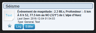
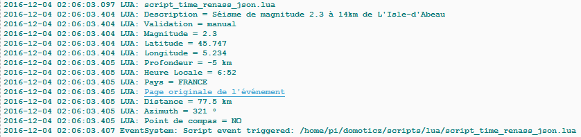
Vous pourrez obtenir ce type d'informations :
Afficheur Virtuel :
Logs :
Étant encore novice en LUA je suis ouvert à toutes les suggestions / conseils / améliorations.


